|
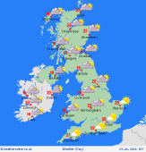 Tuesday Tuesday
Low pressure will bring outbreaks of showery rain to Ireland, Northern Ireland, and northern and western Scotland through the morning, with some heavy and thundery downpours possible. One or two showers affecting the far south and southeast of England too. During the afternoon, the rain will spread across Scotland and into Wales, southwest England and parts of northeast England. Brighter conditions will gradually develop across southern and western Ireland, while much of eastern and southeastern England should be dry with sunny spells. Highs reaching 15C to 25C.
 Tuesday Night Tuesday Night
Showers and any longer spells of rain will ease off overnight for most allowing for a largely dry start to Wednesday morning, though a few scattered showers may affect the far north and some western coasts. Lows of 10C in Scotland to 15C southeast England.
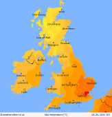
 Wednesday Wednesday
Wednesday will begin largely dry, although cloud will increase across Scotland and northern England with scattered showers. Thicker cloud across Ireland and Northern Ireland will bring outbreaks of rain from the west, falling heavy and persistent in places. Through the afternoon, the rain will spread into Scotland, northern England and north and west Wales, while southern and southeastern areas remain largely dry with sunny spells. Highs at 18C to 25C.
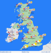
 Thursday Thursday
Thursday sees a showery morning across northern and western areas, these showers pushing in on a brisk west to northwest wind. The east will remain largely dry with the best of the sunshine. As a ridge develops through the day these showers will ease off to allow for largely dry conditions to develop across western areas and winds should ease back. Highs betwen 18 to 27C cooler across northwest Scotland.
|
